Acaté and Matsés Develop Pioneering Mobile Application for Territorial Protection and Preservation of Ancestral Knowledge!
Acate is proud to announce the launch of the Matses Ancestral Territory mobile application, a new tool developed in collaboration with the Matsés people to empower them in the protection of their land and preserve their rich cultural heritage. This innovative app features an interactive map with thousands of locations documented by the Matsés themselves, bringing their history and traditions to life. The development of this app is timely due to the shifting and exceedingly complex situation of land tenure and management in parts of their ancestral territory. The Matsés currently control about half of their ancestral territory in Peru, and there are legal changes now being applied to the parts of their ancestral lands outside of their titled and concession areas. The app is also a major repository of the Matsés’ ancestral knowledge, presented in an appealing format for the younger generations.
The Android phone application can be downloaded from the Google Play Store (There is no Apple iOS version as no Matsés have iPhones):
Key features of the app include more than 12,000 georeferenced points that tell the living history of the Matsés people. The content covers everything from watershed historical events such as pre-contact battles with the Peruvian Army and the site of first peaceful contact with missionaries to the comical, such as the site of the Acaté canoe sinking while on the way to a meeting.
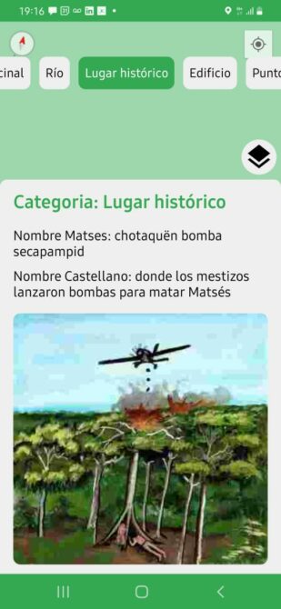
Georeferenced historical site of a Matsés communal longhouse bombed by the Peruvian military during the 1964 Requena-Yaquerana expeditions. ©Acaté
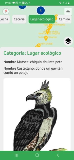
Almost all of the 12,000 points have associated media content to enhance the user experience. Matsés elders worked with Acaté and Matsés artist Guillermo Nëcca Pëmen Mënquë to beautifully illustrate key aspects of the georeferenced points in customized watercolor paintings. In addition, most of the points have audio recordings of Matsés elders describing the point and providing ecological and cultural lessons.
The points are categorized so the user can choose to display all the points from a sector of the territory or all the points within a certain category. The categories include lakes, trails, ecological features and ecotypes (such as flooded forest, aguaje palm swamps, white sand forests), hydrographic features, natural resources, areas with important biodiversity (such as endangered giant river otters), farms, historical sites, geographic characteristics, buildings, reference points, recreation sites, rivers and streams (with the Matsés names), and medicinal agroforestry sites.
Most importantly, this application is easily updated and allows Matsés users to add additional information. The user dialogue prompts the user to either tap on the map to add a point or enter georeferenced coordinates along with images, videos, audio files, and a description.
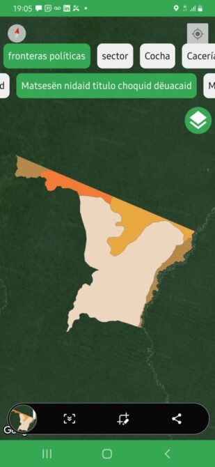
One of the categories of particular importance is the “Political Boundaries” option. This displays the various land tenure designations or current ownership situations within the Matsés Ancestral Territory. Tsusedpabon nidaid is the Matsés name for the entirety of their Ancestral Territory in Peru and Brazil and is approximately 1,870,000 hectares in area or almost the size of the US State of New Jersey or Slovenia. The Brazilian part of their territory is encompassed within the Javari Valley (Vale do Javari) Indigenous Reserve. In Peru, the current situation is complicated by overlapping jurisdictions, buffer zones, and zoning regulations within each area. The Matsés Communal Reserve in Peru is 513,000 hectares in total. This area is zoned into 98,000 ha where the Matsés could engage in commercial activities like livestock or agriculture and 355,000 ha where they have forestry permissions only. The far southern part of the Communal Reserve is a 60,000-ha extension that is zoned in four categories, conservation, forestry, pasture, and agriculture. The far western portion of their territory is now part of the Peruvian government’s Matsés National Reserve, and the southern portion is now part of the Sierra del Divisor National Park. Each of these protected areas has a buffer zone that extends into the Matsés Communal Reserve.
Further complicating the situation, the Peruvian Ministry of Culture has now created new protected areas that overlap almost entirely the Peruvian Park Service’s aforementioned protected areas. Without a tool like the app, it would take a wall full of maps and a table full of documents and explanations to even begin to unravel and understand the bureaucratic morass of the land tenure situation.
Government-demarcated concession zones within a section of Matsés titled land. Without a tool like this app, which places this information at the Matsés fingertips, it would be extremely difficult for Matsés stakeholder communities to be fully aware of the highly complex – and evolving – land tenure situation of Matsés ancestral lands. ©Acaté
As was the case in the formation of the Matsés National Reserve in 2009, the ground truth is that neither of the recent land tenure decisions were transparently approved with full informed consultation by the Matsés communities as required by Peruvian law. The general Matsés population, outside of individual elected leaders, was kept mostly in the dark or provided incomplete information. In the course of Matsés Indigenous Mapping Initiative, many Matsés were furious to learn for the first time, seven years after, that the rights to their birth lands had been formally ceded to the state with the establishment of the Matsés National Reserve.
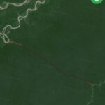
The app includes the proposed road-route from the frontier settlement of Jenaro Hererra on the Ucayali river to Angamos. This road would open up the Matsés ancestral lands to a wave of settlers and extractive operations. If constructed, this road looms as an existential threat to the Matsés forests and way of life. The light beige highlights already cut sections of the road. ©Acaté
At present, the rezoning or establishment of parks by the state in these highly remote forested areas may seem to inconsequential. The Matsés ancestral lands, however, are rich with untapped petroleum, carbon, timber, and settleable land. As the government slowly and deliberately removes the Matsés’ traditional land claims, future governments would be able to block the Matsés access or pass control of these areas to extractive interests. In the Amazon, the uncomfortable reality of the ground is that there often exists a disconnected between protected status in law and actual conferred protection. When land is appropriated from the traditional homelands of indigenous peoples to create parks under national control, paradoxically, it can make the land more vulnerable to resource extraction. The laws of government may not be enforced or can be annulled or rewritten with a new administration in response to powerful industry lobbying. Globally, there is ample precedent of how the creation of state parks under the conservation banner of universalism and international collaboration have resulted in loss of traditional land rights and even in the displacements of entire groups. Having all these land tenure designations readily available in the app, along with the corresponding legal documents, will help the Matsés communities to understand what has happened to their territory and give them the opportunity to respond more effectively against the increasingly sophisticated threats against their territorial sovereignty.
Interactive Time-Lapse Map Shows How the U.S. Took More Than 1.5 Billion Acres From Native Americans (click to view)
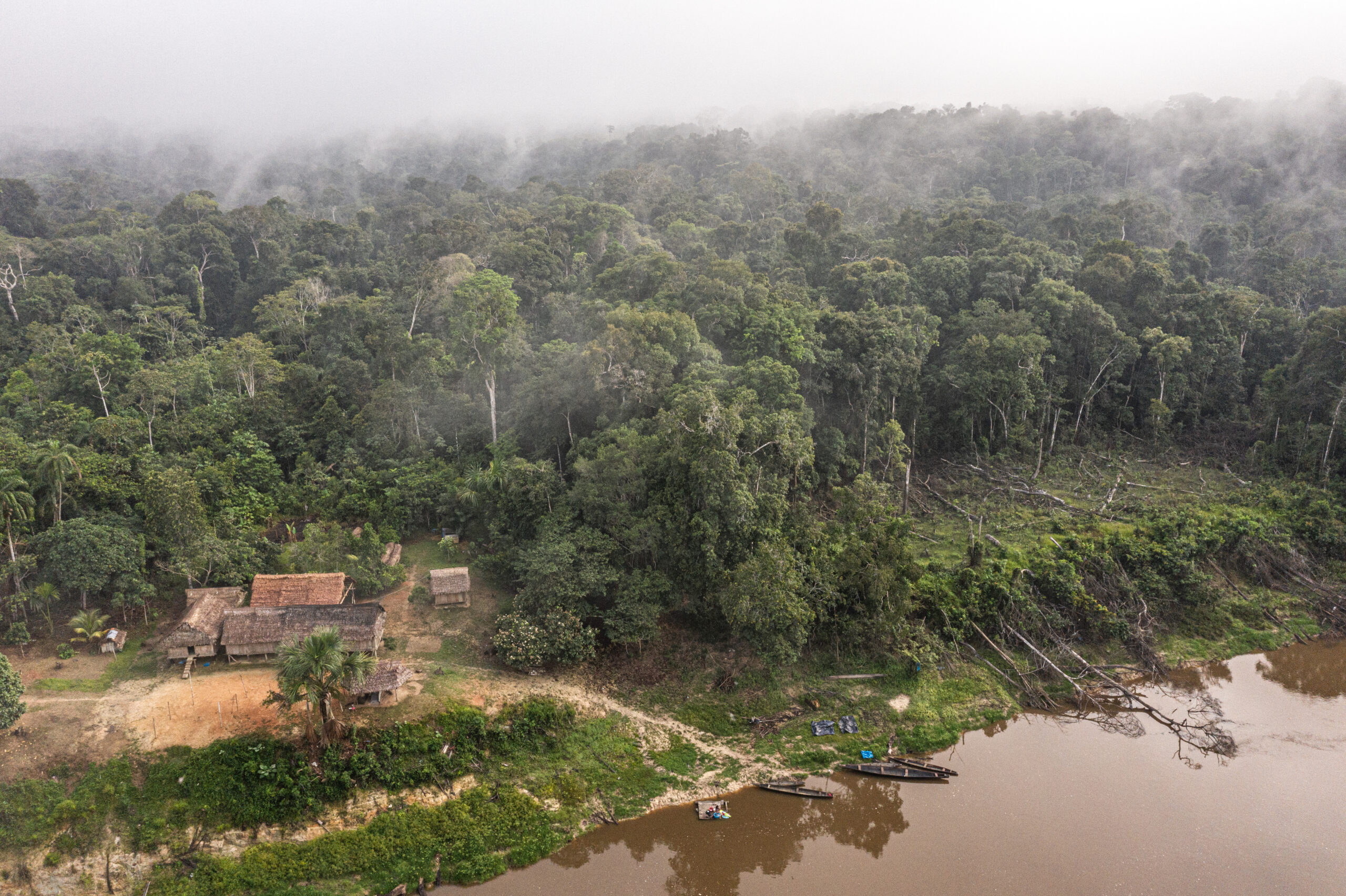
For uncounted generations, the Matsés fought to defend their land against the encroachment of outsiders intent on resource extraction. It is for this reason that this area, which contains among the most biodiverse and carbon-rich forests in the world, remains intact today. ©Acaté
Background
The app is the logical progression of the landmark Matsés Indigenous Mapping Initiative. Recognizing the critical need to demarcate their territories and retain their ancestral knowledge of their lands before it faded with passage of the elders, the Matsés indigenous people with the assistance of Acaté Amazon Conservation set out to map, for the first time, the Matsés ancestral lands in Peru.
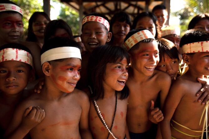
The initiative brought together Matsés elders and youth, ensuring that the centuried-old connection between their culture and lands is not severed. ©Acaté
Teams of Matsés elders and youth set out across their territory to locate and georeference with GPS units sites of historical events, natural resources, current and past villages, hunting camps, trails, rainforest habitat types and other sites of cultural and ecological significance. In total, after five years of intensive work, the Matsés recorded and georeferenced over 12,000 culturally significant data points.
At the start of the Matsés Indigenous Mapping Initiative in 2015, the Matsés’ rich knowledge of their lands and ancestral history resided only in the memory of their living elders. The elders who held the most knowledge were reaching an age where it is increasingly physically difficult to walk to some of the most cultural and historical sites. An incalculable amount of culturally and ecologically significant information was poised to be forever lost. Much of this knowledge is now available within the app along with the recorded voices of the elders.
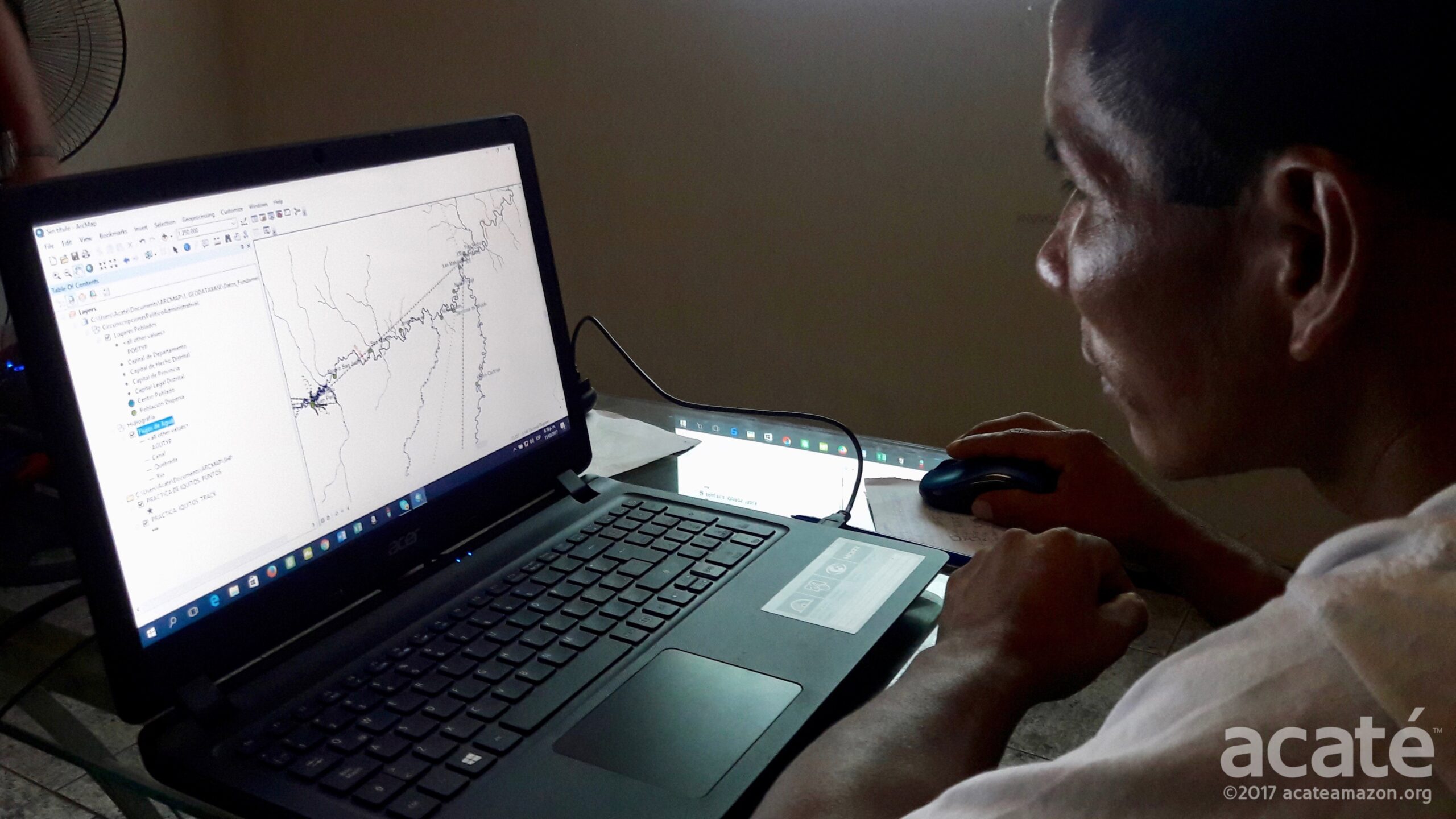
Through the Matsés Indigenous Mapping Initiative, over 150 Matsés were introduced and trained in basic computation, 45 in GPS usage, and 8 in GIS software. ©Acaté
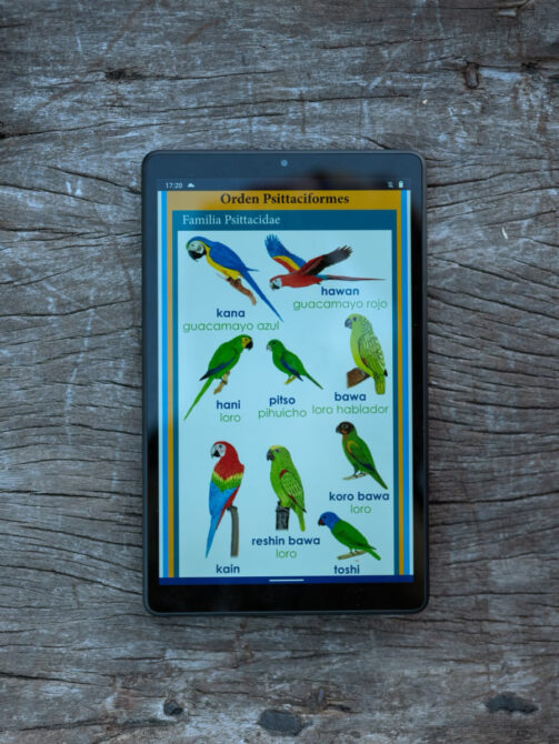
In 2015, back when the Matsés Indigenous Mapping Initiative was first launched, few Matsés had a cell telephone. In the past few years this situation has changed quite a bit, although their territory today still, for the most part, lacks cell phone and internet access. The Peruvian Ministry of Education schools in Matsés villages now provide tablets for the students as they do for all communities across Peru, but Matsés-language specific content is lacking. To fill this void, Acaté Amazon Conservation created to date four novel mobile educational applications for the Matsés that are downloadable for Android phone platforms here at the Google Play Store. This includes a series of interactive ecologic applications as well as the first-ever dictionary phone app created for an Amazonian indigenous language.
A recent Washington Post article profiled the Iskonawa cell phone app. The Iskonawa are another Panoan group in the Peruvian Amazon who, unlike the Matsés, have only a handful of remaining native speakers. The Washington Post piece incorrectly credited the development of the app to another party; the app was developed by Dave Fleck and the Acaté team and is downloadable here. We were pleased to read in the article that the app has become “hugely popular” in the Iskonawa community. Acaté has published apps in four Amazonian indigenous languages. ©Washington Post
We envisioned a phone app that would enable the Matsés to access all information from the Matsés Indigenous Mapping Initiative instantly and provide the capacity to update that application with their own observations and knowledge utilizing an interactive feature. An interactive mobile telephone/tablet application would confer many advantages to traditional printed maps. The Matsés territory is so vast and their cultural and environmental knowledge so rich and nuanced that it is not practical to represent in a usable format on a single or even a series of printed maps. Land use and knowledge is highly dynamic but printed maps are comparatively static, costly to revise, and to reprint with updates. If an app could be developed, then the user could record new geographic points and upload content, photos, and audio files associated with the new recorded points, which is far more advantageous to revising and reprinting printed maps.
Challenges
The Acaté team had developed successful interactive language apps but taking on the development of an interactive geo-referencing application for a remote and large indigenous territory was entirely new for us and, as can be appreciated, brought a host of complexities and challenges. To our knowledge, no such model existed for other indigenous communities and we would be developing it de novo and on the most shoestring budget.
We will just briefly touch on a few of the challenges for successful development of the app. One challenge was the very large size of the Matsés Ancestral Territory, of which only a fraction of this vast region is accessible by navigable waterways or marked paths. In addition to the sheer magnitude of the areas there were considerable difficulties consolidating and organizing all the data and then converting it to the native Android format such that it can be displayed on the app.
Importantly, given the remote geography of the Matsés territory, the application was built by necessity to function with limited or without any internet connection. If too much offline content is included the app becomes too large (“heavy”) and cannot be loaded on phones with limited memory (such as would be used regionally by the Matsés) but, if it is designed for efficiency with assets on the server, then the offline functionality becomes too limited. We strove to find the right balance, so the download size is reasonable, and the basic functionality is there without an internet connection.
Future Directions
The development of this app takes yet another step forward to support present and future generations of Matsés to protect their lands from extractive industry and future attempts to dispossess them. The Matsés are now sharing the app between their phones (as access to Google Play Store is limited in the territories) among their communities.
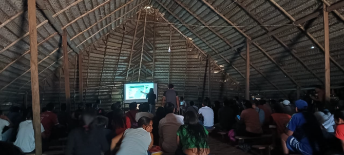
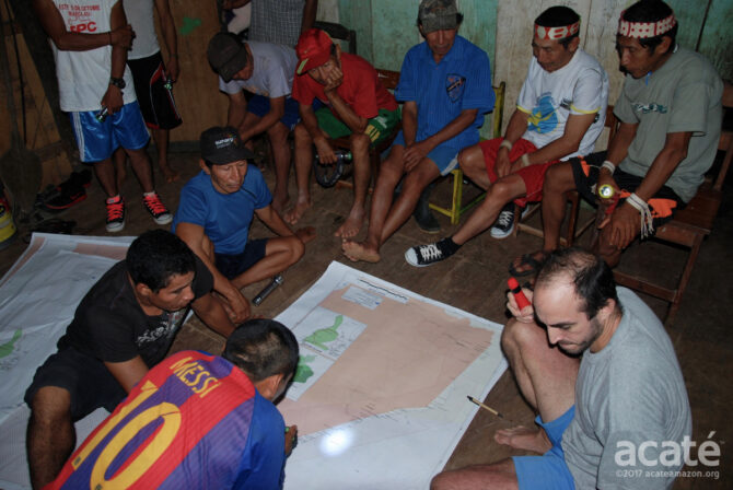
Matsés leaders and Acaté staff presenting the app at a recent assemblea (meeting) of representatives from all the Matsés communities in Peru.©Acaté
Engaging younger generations is central to bridging the increasingly generational divide among indigenous groups that has occurred with increased exposure to the outside world. The app offers young Matsés an opportunity to continue their legacy and connection by adding their history and including their perspective of their territory through the app. Through engaging younger generations, the app helps inspire youth that their identity as Matsés can lie in both traditional and modern systems, and that to choose one is an artificial choice; one can thrive in the outside world yet retain a proud identity as Matsés.
We are grateful for our funders whose support made this work possible and look forward to continuing to enhance the application, which is being regularly updated on the Google Play Store. As far as we know, this is the first interactive map application for an indigenous territory, so the lack of a model to copy made it a real challenge for the Acaté team to design and program de novo, particularly for territory that is remote, complex, and with limited internet connectivity. With these challenges overcome, we hope that other indigenous groups and organizations will be able to use it as a model to create similar applications for other indigenous areas. The ICCA Registry and Digital Democracy created a mobile app tool for groups wanting to include their territories in the ICCA database. This app allows users to add their date for inclusion with the ICCA registry without having to use a GPS unit or GIS software.
If you missed it, take a look at our September 2023 field report on the launch of this large-scale initiative to support food security, sustainable income opportunities, and women’s empowerment! Stayed tuned for a forthcoming update soon on this extraordinary initiative!
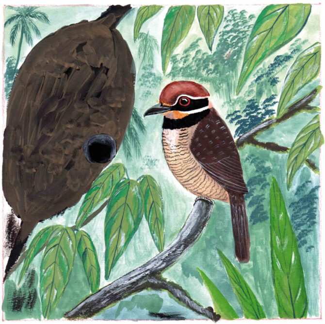
Acaté recently shared nearly 700 exquisite watercolor paintings by Matsés artist Guillermo Nëcca Pëmen Mënquë showcasing the incredible biodiversity of the Amazon Rainforest! Take a moment to view Guillermo’s extraordinary work in the Matsés Rainforest gallery. Here, a Chestnut-Capped Puffbird (Bucco macrodactylus), known to the Matsés as uen bënën shui, lays its eggs in a hollowed-out termite nest. ©Acaté
Acaté Amazon Conservation is a non-profit organization based in the United States and Perú that operates in a true and transparent partnership with the Matsés people of the Peruvian Amazon to maintain their self-sufficiency and way of life. The Matsés safeguard a critical conservation corridor and shield some of the last remaining uncontacted tribes in isolation from unwanted encroachment from the outside world. Acaté works to protect their forests and way of life through supporting on-the-ground initiatives that are led by the Matsés indigenous people.
Operating on the frontlines of conservation, Acaté’s initiatives over the past decade have included the first indigenous medicine encyclopedia as well as projects with original methodology in sustainable economic development, traditional medicine, medicinal agroforestry, nutritional diversity, regenerative agriculture, integrated aquaculture systems, biodiversity inventory, education, native language literacy, participatory mapping, and protection of uncontacted tribal groups in isolation. All of our initiatives are developed with, led and implemented by the Matsés indigenous people. Donations are tax-deductible and go directly to fund these on-the-ground initiatives that operate with unparalleled transparency.
All content and images copyright 2024 Acaté